The Geographical Information Systems Laboratory
GIS-technologies – isn’t simple computer database. It’s a huge capabilities for analysis, planning and regular information update. GIS-technologies today have practical application in all spheres of life and really help to solve different tasks effectively.
Work, conducted by GIS laboratory:
- Creation of interactive maps;
- Creation of a technique of preparation autonavigating maps with use GIS technologies
- Creation of a technique of multilevel monitoring of natural objects condition (vegetation and soil) of “Altyn asyr” Turkmen lake and Nearhazar lowland
- Creation of a technique of multilevel monitoring of irrigated land condition in Turkmenistan (by main soil types)
CREATION OF INTERACTIVE MAPS The interactive map includes archaeological sites of Turkmenistan which are on the Great silk way. It was created by application of JavaScript library for Internet mapping OpenLayers. Map contains layers of archaeological sites, cities of Turkmenistan (capital, welayat centres, etrap centres), water objects (rivers and lakes), highways, railways, the Great silk way route, welayats boundary of Turkmenistan. Map can be opened in any modern Internet browser and general descriptive information on necessary monuments can be accessible a comfortable way.
CREATION OF A TECHNIQUE OF PREPARATION AUTONAVIGATING MAPS WITH USE GIS TECHNOLOGIES The developed technique includes sequence of operations on collection and handling of the primary data, constant actualization of video fixing data that provides regular update of key objects of the content of a map, infrastructure objects and points of interest. On the basis of the developed technique the autonavigation map of the city of Turkmenbashi and a tourist zone Awaza has been created. Approbation of the created autonavigation map has been successfully accomplished on autonavigation system "Garmin" and also on mobile devices - the smart phone and a tablet.
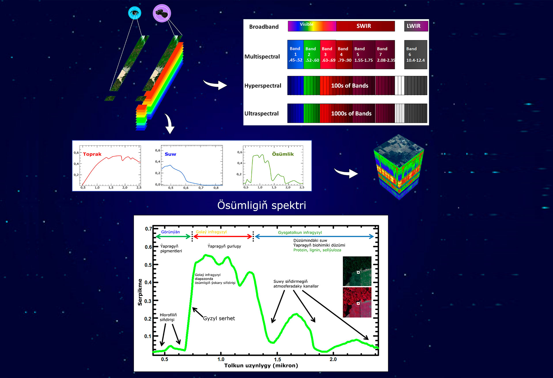
CREATION OF A TECHNIQUE OF MULTILEVEL MONITORING OF NATURAL OBJECTS CONDITION (VEGETATION AND SOIL) OF “ALTYN ASYR” TURKMEN LAKE AND NEARHAZAR LOWLAND Vegetation index – measure, calculated in result of operations with different spectral bands of remote sensing data and related with parameters of vegetation in given pixel of the image. One of the main application of this indexes – compare of the same object on many images for one period of time. For conducting such kind of analysis in Turkmenistan, decision made to establish study area in the Nearhazar lowland. In the area of polygon spectral characteristics of grassland vegetation collected and three most wide spread species was Salsola arbuscula Pall., Artemisia kemrudica Krasch., and Limonium, based on that species vegetation indexes for studying and vegetation condition assessment calculated.